 Awesome or Off-Putting is a weekly delve into cryptozoology, ufology, medical marvels, scientific wonders, secret societies, government conspiracies, cults, ghosts, myths, ancient artifacts, religion, strange facts or just the plain unexplainable.
This week: Ancient Artifacts
The first recorded sighting of Antarctica is generally accepted as having been in the year 1820. The last time Antarctica wasn't covered in a mile thick sheet of ice was approximately 4000 years BC – so say some scientists. Not too strange yet – right?
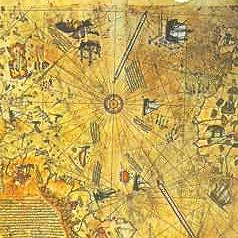
Ah, but it is, because in the year 1513 a Turkish admiral named Piri Reis managed to sketch out Antarctica's entire northern coast on a gazelle skin in perfect detail. And he sketched the continent's underlying land mass – not the ice shelf that'd been covering it for five and a half millennia at the time.
And that, you see, is the mystery of Piri Reis' map.
In 1929 a palace in Istanbul, Turkey was being converted into a museum. In the palace, a map was found which detailed the eastern coast of South America, the western coast of Africa, and the Northern coast of Antarctica. Subsequent research showed the map was genuine, and dated back to 1513. It's been drawn by a high ranking Ottoman-Turkish admiral named Piri Reis, who was a passionate cartographer.
As we stated before, the northern Antarctic coast depicted in the map was the actual land mass, not the ice shelf it's hidden beneath for the past six thousand years. On top of that, the map was drawn more than 300 years before the cold continent was believed to have been discovered. Obviously this opens several questions, like how'd Reis know Antarctica was there, and how'd he know exactly what it looked like under it's snowy cap?
The admiral makes no secret as to his map sources. He says he used about 20 charts and maps to make his gazelle-skinned creation. Those maps included eight Ptolemaic maps, four recent Portuguese maps, an Arabic map of India, and even a map by Christopher Columbus which depicted much of the new world. Best as we can tell, no maps are specifically given credit for the Antarctic portion.
All the map strangeness has puzzled quite a few people – including a professor at Keene college by the name of Charles H. Hapgood. He requested the US Air Force verify the map's accuracy. This is their response to him (dated 1960):
Dear Professor Hapgood,
Your request of evaluation of certain unusual features of the Piri Reis map of 1513 by this organisation has been reviewed. The claim that the lower part of the map portrays the Princess Martha Coast of Queen Maud Land, Antarctic, and the Palmer Peninsular, is reasonable. We find that this is the most logical and in all probability the correct interpretation of the map. The geographical detail shown in the lower part of the map agrees very remarkably with the results of the seismic profile made across the top of the ice-cap by the Swedish-British Antarctic Expedition of 1949. This indicates the coastline had been mapped before it was covered by the ice-cap. The ice-cap in this region is now about a mile thick. We have no idea how the data on this map can be reconciled with the supposed state of geographical knowledge in 1513.
Harold Z. Ohlmeyer Lt. Colonel, USAF Commander
Even if Reis' Antarctic source was another map – who made that one? In 4000 BC (generally considered the last time the southern-most continent was ice-free) who made the original incredibly accurate map? Some say the first 'civilisation' arose in the mid-east about 3000 BC – so it definitely wasn't them. The already puzzling case keeps getting more and more confusing.
Was there another civilisation in 4000 BC? Was that civilisation technologically advanced enough to chart such a far-off continent? Maybe Antarctica was inhabited when the area was more climate-friendly. Is it possible its ancient inhabitants got buried in the ice themselves? Perhaps when the ice melts away we'll find an ancient semi-advanced civilisation thawing in the puddles. If so, how'd their map get to Turkey, and how'd it not fall completely to pieces in the five and a half thousand years it waited for Reis to copy it?
There's a thousand theories but none are substantiated. If we have to wait for the ice caps to melt before we have any concrete answers, we're clearly obligated to speed things up.
Now if you'll excuse us, we're gonna go outside and run our hummer.
Read more:
Piri Reis Antarctic Map – World Mysteries
[story by Shawn Lindseth]

aaronmichaeltoner says
Can you do an article on gost cemeteries and such. I find them tantalizing oh yeah and if you have anything on barry bonds. he’s very good thank you